Route & information
Location: Kamari
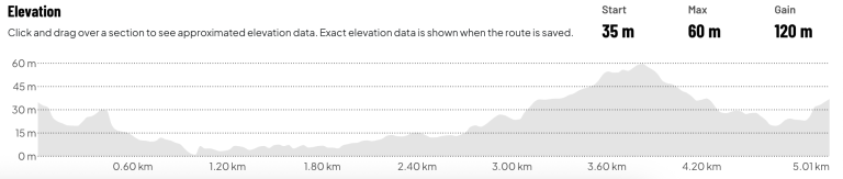
The 5 km route starts at an altitude of approximately 35 m and follows a gentle downhill course for the first 800 meters, allowing runners to quickly find their rhythm.
From the 1st kilometer to approximately the 2.5th kilometer, the route remains relatively flat, with small changes in gradient and limited elevation differences.
After the 2.8th kilometer, the main uphill challenge of the route begins. The ascent is progressive and continues for approximately 1 kilometer, leading participants to the highest point of the route, which is between 3.7 and 3.9 kilometers at an altitude of approximately 60 m.
A downhill section follows until the 4.6th kilometer, with the final meters of the route featuring gentle undulating gradients and a small final uphill approach to the finish line.
Route technical characteristics
- Route length: 5.01 km
- Start altitude: 35 m
- Finish altitude: 35 m
- Maximum altitude: 60 m
- Minimum altitude: approximately 2-5 m
- Total positive elevation gain: 120 m
- Total negative elevation gain: 120 m
- Route type: asphalt / urban
- Difficulty level: Moderate