Routes 2026
Routes 2026
Open Water Swimming of Santorini Experience
Location: Volcano – Old Port of Fira
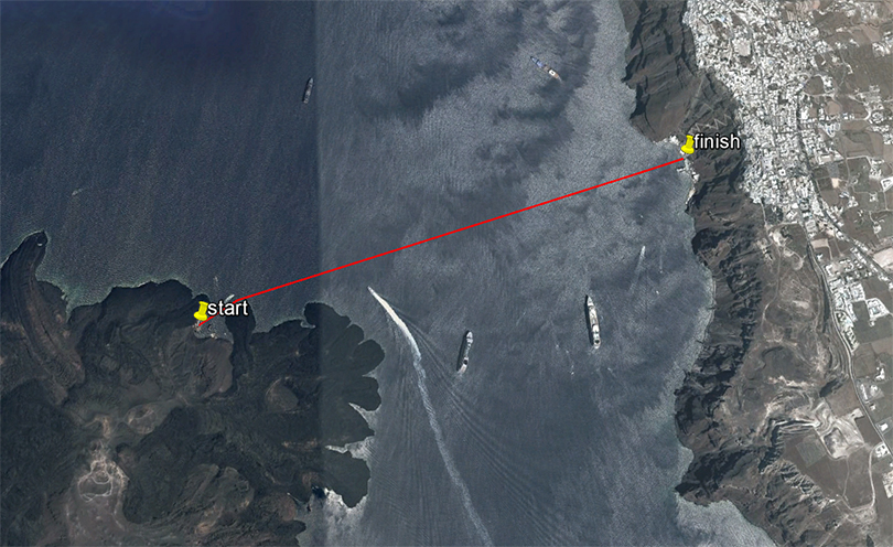
The open water swimming route of the Santorini Experience is 1.5 miles (2.4 km).
Start/Finish
The start* will be given in the water at the small harbor of the volcano. The finish will be at the pier of the old port of Fira under a specially designed finish arch. A pool-type ladder is available for your exit.
Along the route, there will be experienced lifeguards and floating vessels for the safety of the swimmers. If you feel unwell or cannot continue, wave your hands up and down or head towards the nearest floating vessel.
*Swimmers will be transported by boat to the starting area.
Other Information
The race will be timed. Swimmers will be divided into different categories depending on the final number of participating swimmers, and there will also be a separate categorization for those wearing wetsuits (wetsuit category).
Athletes must be at the old port at least 1 hour before the scheduled start time.
Participants can use the cable car connecting Fira to the old port.
Spectators can descend to the port via the stairs or the cable car, or enjoy the race from any point in Fira or Santorini that "overlooks" the volcano.
5 km Route
5 km Trail Race of Santorini Experience
Location: Oia - Desalination Plant
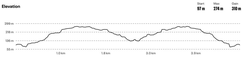
The 5 km route starts with a slight downhill for approximately 250 meters on a wide dirt road, then follows a steep uphill path of 1,250 meters with an average gradient of 12%. The path then narrows and the terrain changes with many stones, requiring increased attention. The gradient is downhill until the turning point, which is at the middle of the route (2.5 km) where there will also be a feeding station.
On the return, we encounter the maximum gradient just before the 3.5 km mark, which approaches 40% (!) for 100 meters. The last 1.5 km of the route are downhill.
Technical characteristics of the route:
Starting-finishing altitude: 146 m.
Turning point altitude: 173 m.
Maximum altitude: 293 m.
Minimum altitude: 135 m.
Total positive elevation gain: 313 m.
Maximum gradient: 37.6%
Route terrain: dirt path with embedded stones in some places
10 km Route
10 km Trail Race of Santorini Experience
Location: Oia - Desalination Plant
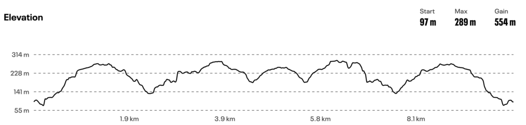
The 10 km trail race starts with a slight downhill for approximately 250 meters on a wide dirt road, then follows a steep uphill path of 1,250 meters with an average gradient of 12%. The path then narrows and the terrain changes with many stones, requiring increased attention. The gradient is downhill until the 2.5 km mark where the 1st feeding station will be. Afterwards, the route goes onto asphalt for about 660 meters with a moderate uphill gradient, before re-entering a path whose ground is soft and somewhat loose earth, so a little caution is needed as it is relatively slippery, with a very steep gradient for approximately 700 meters with breathtaking views.
The intense uphill ends at the 3.8 km mark at the chapel of Profitis Ilias, followed by a concrete downhill road until the 4.5 km mark (2nd feeding station) and then approximately 500 meters remain until the turning point (Colored balloon and human marker). The return route is the same except for the point after the 6th km where, before the chapel of Profitis Ilias, we take the paved path (also requiring considerable attention) which is on the right until we reach the asphalt again at the 7th km and after about 600 meters we re-enter the path for the return where we encounter the maximum gradient just before the 8.5 km mark, which approaches 40% (!) for 100 meters. The last 1.5 km of the route are downhill.
Technical characteristics of the route:
Starting-finishing altitude: 146 m.
Turning point altitude: 245 m.
Maximum altitude: 293 m.
Minimum altitude: 135 m.
Total positive elevation gain: 570 m.
Maximum gradient: 37.6%
Route terrain: dirt path with embedded stones in some places, asphalt, paved.
15 km Route
15 km Trail Race of the Santorini Experience
Location: Oia - Desalination Plant
The 15 km route begins with a slight downhill for approximately 250 meters on a wide dirt road, then follows a steeply uphill path 1,250 meters long with an average gradient of 12%. Subsequently, the path narrows and the terrain changes, featuring numerous stones, so increased caution is required. The gradient is downhill until the 2.5 km mark, where the 1st aid station will be located. The route then transitions to asphalt for about 660 meters with a moderate uphill gradient, before re-entering a path where the ground is soft and somewhat loose soil, so a little caution is needed as it is relatively slippery, with a very steep gradient for approximately 700 meters offering breathtaking views. At this point, pay attention to stay as far left on the path as possible.
The steep uphill ends at 3.8 km at the chapel of Profitis Ilias, followed by a downhill cemented path until 4.5 km, and then approximately 500 meters remain until the 2nd aid station located at 5 km. The next approximately 2 kilometers are also quite uphill on stable but rather hard ground, passing through Imerovigli with the view continuing to be stunning. We continue until the entrance of Fira to reach the church of Agios Gerasimos, where the 3rd aid station and the turnaround point are located. The return route is the same except for the section after the 11th km, where before the chapel of Profitis Ilias, we take the paved path (also requiring considerable caution) located on the right until we reach the asphalt again at 12 km, and after about 600 meters, we re-enter the path for the return where we encounter the maximum gradient just before 13.5 km, which approaches 40% for 100 m (!). The last 1.5 km of the route are downhill.
Technical characteristics of the route:
Start-finish altitude: 146 m.
Turnaround point altitude: 277 m.
Maximum altitude: 334 m.
Minimum altitude: 135 m.
Total positive elevation gain: 834 m.
Maximum gradient: 37.6%
Route terrain: dirt path with embedded stones in some parts, asphalt, paved.
Ancient Thera Run 5K powered by Sandblu Santorini
Location: Kamari
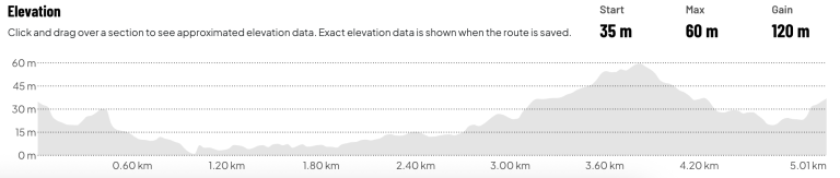
The 5 km route starts at an altitude of approximately 35 m and follows a gentle downhill course for the first 800 meters, allowing runners to quickly find their rhythm.
From the 1st kilometer to approximately the 2.5th kilometer, the route remains relatively flat, with small changes in gradient and limited elevation differences.
After the 2.8th kilometer, the main uphill challenge of the route begins. The ascent is progressive and continues for approximately 1 kilometer, leading participants to the highest point of the route, which is between 3.7 and 3.9 kilometers at an altitude of approximately 60 m.
A downhill section follows until the 4.6th kilometer, with the final meters of the route featuring gentle undulating gradients and a small final uphill approach to the finish line.
Route technical characteristics
- Route length: 5.01 km
- Start altitude: 35 m
- Finish altitude: 35 m
- Maximum altitude: 60 m
- Minimum altitude: approximately 2-5 m
- Total positive elevation gain: 120 m
- Total negative elevation gain: 120 m
- Route type: asphalt / urban
- Difficulty level: Moderate